Amendment C106 mild - Mallee CMA Flood Mapping Update
Current Status
The amendment has been approved by the Minister for Planning (7 June 2022) and notice of her decision was published via the Victorian Government Gazette on 21 July 2022.
Background
Amendment Progress
The Mildura Rural City Council has prepared Amendment C106mild to the Mildura Planning Scheme and Council has notified affected landowners that floodway overlay boundaries are being updated. This may affect how landowners develop their land in the future. The amendment closed exhibition 25 October 2019, with submissions received having since been assessed. The amendment was adopted by Council on 22 January 2020. Council has prepared amendment documents and requested approval of the amendment from the Minister for Planning in July 2020 via the Department of Environment Land Water and Planning (DELWP). Since that date Council has responded to a number of requests for further information from the Department.
Please refer to the link at the bottom of the page to access the amendment documents via the DELWP website.
Technical Information
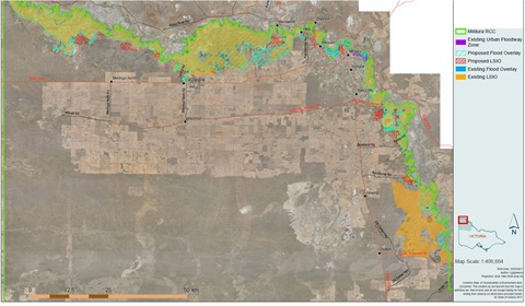
Land affected by the amendment includes various parcels of public and privately owned land along the Murray River and its tributaries in the municipality. The land is generally located between Hattah and the South Australian border.
The Mildura Planning Scheme provides strategic direction for future town planning of Mildura and its surrounding townships. The scheme currently contains Floodway Overlay (FO) and Land Subject to Inundation Overlay (LSIO) controls to manage the potential impact of Murray River flooding.
These overlays aim to ensure that land subject to flooding is developed in a way that minimises the risk of damage to properties, protecting new development from inundation, flooding and significant rise in flood levels or flow velocities, which may adversely affect other properties.
The amendment proposes to implement the results of accurate flood modelling following receipt of high quality Light Detection and Ranging (LiDAR) data by the Mallee Catchment Management Authority (MCMA). The data has provided increased accuracy of the existing flood controls within the planning scheme. The improved data therefore updates the boundaries of the Land Subject to Inundation Overlay (LSIO) and Flood Overlay (FO).
Owners of land currently that has, or it is proposed to have, either a Floodway Overlay (FO) or a Land Subject to Inundation Overlay (LSIO) or both have been notified of the update to overlay boundaries.
For land that currently has an FO or LSIO this may indicate a change to the boundary, or removal of the overlay, currently on land. These overlays may affect how landowners develop their land in the future, as the provisions of the LSIO and FO require that some development works will need a planning permit.
To see how land is affected
Following gazettal of the Amendment C106mild, the new/updated FO and LSIO overlay boundaries are now reflected in the Mildura Planning Scheme. Any future planning permit applications for land use and development must comply with the changed boundaries. To see the updated overlay information please visit the Victorian State Government's VicPlan website: https://mapshare.vic.gov.au/vicplan/
Any queries regarding permit applications for works or land use and development should be directed to Council's Statutory Planning Team, who are responsible for determining applications and issuing permits in accordance with the Planning Scheme.
Timeline
|
Event
|
Comment/Date
|
|
Authorisation by Minister for Planning to Prepare Amendment
|
Requested 15 July 2019
|
|
Public Exhibition for Comment
|
Submissions closed 25 October 2019
|
|
Adoption by Council
|
22 January 2020 |
| Amendment Documents submitted to the Department of Environment Land Water and Planning (DELWP) requesting approval of the Amendment.
|
13 July 2020 |
| Further information requested by the Department and provided by Council. Resubmitted for Approval. |
27 April 2021 |
| Gazetted
|
21 July 2022 |